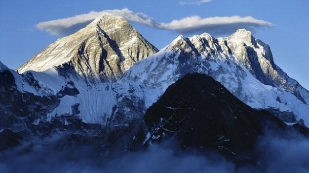
Google offers peek into world’s highest peak in Nepal
 Nepal’s Everest region, home to the world’s highest peak and one of the country’s busiest trekking routes, is not only remote, it is also expensive; it demands time, energy and investment from the visitor.
 Nepal’s Everest region, home to the world’s highest peak and one of the country’s busiest trekking routes, is not only remote, it is also expensive; it demands time, energy and investment from the visitor.
But now the sights of the Himalayan region are now available on a virtual tour, thanks to Google Street View. Visitors to the website are treated to views of snow-capped mountains, dramatic waterfalls, and soaring suspension bridges.
The tech giant Google partnered with Story Cycle, a Kathmandu-based start-up, and Apa Sherpa, an elite climber who holds the record of climbing Everest 21 times, to capture thousands of images of the region populated by the Sherpa community who excel at mountaineering.
“Our region is famous for being home to Everest, but it’s also home of the Sherpa community and has been for centuries. The region has much more to offer than just the mountain,” Apa Sherpa wrote in a blog post published by Google.
“A team from Google had a 15-lens ‘Trekker’ that mapped the trekking route while our colleagues with two DSLR cameras used a fish eye lens to capture panoramic images and stitched it together for the street view,” Saurav Dhakal, the founder of Story Cycle told The Anadolu Agency.
A team of 13 experts, including three from Google and a Nepali artist, trekked through the narrow mountain trails and spent 11 days in late March and early April last year.
While the team with the “Trekker” — a special camera used for capturing Street View images — embarked on the trekking route to the Everest base camp, Apa Sherpa led the second group, which shot local lodges, schools and the climber’s home and monastery in Thame.
“Our goal is to promote map-based storytelling. We spoke to 60 locals and documented a total of 1,000 map points,” said Dhakal. They were accompanied by R.K Thapa, an artist who live-painted the scenes that were later used in the video.
The Google Street View of Everest shows a spectacular multimedia video of the landing of an aircraft at Tenzing-Hillary Airport in Lukla, the gateway to Everest. The Everest Summiteers’ Lodge, run by a relative of Apa Sherpa, has also been featured in the Google Maps’ digital initiative.
As the impressive mountains loom behind, a jocular Apa Sherpa talks about the hardship of life in the Khumbu Valley. “We can only grow potato and radish here,” he tells viewers. “Education is important so that young men don’t have to take risks (of climbing mountains),” the 55-year-old says.
Apa Sherpa, who now lives in the United States with his wife and children, has set up Apa Sherpa Foundation to support school education for local children in his home village of Thame, in the Everest region.
Sherpa has donated laptops and furniture for a local school and paid the salaries for teachers of Sherpa language, according to Story Cycle’s Dhakal.
The spring climbing season, when hundreds of climbers attempt to scale the 8,848 metre mountain, runs between April and May (Anadolu Agency).
[adrotate banner=”46″]