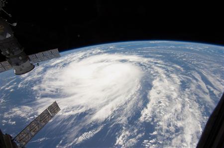
Hurricane Katia, the second hurricane of the season, “strengthened considerably” to a category 4, the second-highest level storm, as its path churned over the Atlantic Ocean and became a major hurricane by Monday night, the National Hurricane Center warned.
The U.S. National Hurricane Center (NHC) has warned that large swells of waves generated by Hurricane Katia are expected to hit most of the U.S. East Coast, Bermuda, the Greater Antilles and east-facing beaches of the Bahamas in the Atlantic Ocean on Hurrricane Katia path as it moves north-west during the next few days. NHC warned that these waves are likely to cause life-threatening surf and rip current conditions powered by Hurricane Katia’s maximum sustained winds which had increased to 135 mph (215 kph). Some strength fluctuations are expected before the storm slowly weakens. Meanwhile swells affecting the northern Leeward Islands should continue to subside overnight. As Hurricane Katia became a category four storm on the Saffir-Simpson scale when its maximum sustained winds increased to 135 mph with higher gusts. The storm system was about 450 miles south of Bermuda, traveling steadily northwest at 10 mph.
Hurricane Katia strenghtens to Category 4
Hurricane Katia’s path emerged in the far eastern Atlantic Ocean on August 29 as a tropical depression before slowly strengthening into a hurricane. Dry air and shear caused the storm to weaken several times before the system quickly restrengthened into a category two hurricane on Sunday, and then a category four hurricane on Monday. As of 11 p.m. AST on Monday (0300 GMT Tuesday), the center of Hurricane Katia was located about 450 miles (725 kilometers) south of the British overseas island of Bermuda, or north of the Caribbean Sea. Katia is moving on its path toward the northwest at a speed near 10 miles (17 kilometers) per hour, a general motion which is expected to continue through Wednesday.
Maximum sustained winds on Hurricane Katia path have increased to 125 miles (205 kilometers) per hour, with higher gusts, making it a category three hurricane on the five-step Saffir-Simpson scale of intensity. The storm is not expected to become a category five hurricane.
Hurricane Katia path : Far enough from land ?
“Satellite images indicate that Hurricane Katia has strengthened considerably during the past several hours,” informed John Cangialosi, a hurricane specialist at the U.S. National Hurricane Center (NHC). “Fluctuations in the intensity of Hurricane Katia path are likely during the next 12 to 24 hours, perhaps due to eyewall replacement cycles, as the major hurricane path remains in a favorable environment.”
On late Tuesday or early Wednesday, NHC forecasters expect slow weakening to commence as Hurricane Katia path moves into an environment of moderate shear and slightly cooler waters. But dangerous rip currents remain the main hazard as Hurricane Katia path is forecast to stay far enough from land.
A general motion toward the west-northwest and a decrease in forward speed are expected during the next couple of days. This general motion is expected to continue through Wednesday before the storm slowly weakens. There are no coastal watches or warnings in effect.
Hurricane Katia Path: East Coast not out of the woods
Another Hurricane specialist Todd Kimberlain claims it’s looking less likely that HurricaneKatia will hit land but that wind from the storm could still affect the U.S. East Coast as it moves north along Hurricane Katia path. Forecast maps show it veering to the northeast, away from the U.S. in the coming week. Parts of the U.S. east coast on the Atlantic Ocean are still recovering from Hurricane Irene, which made landfall on Aug. 27, leaving 45 people dead from North Carolina to Maine and cutting power to 6.69 million homes and businesses.
Meanwhile tropical storm Lee weakened to a depression after making landfall and soaking Louisiana and much of the Gulf Coast. Flooding is expected to move into the Tennessee Valley, the Appalachian mountains and New England. Lee was about 75 miles south of the Birmingham, Alabama, municipal area, with remnants of the storm moving east-northeast at 12 miles per hour, the NHC said in its last advisory. “Heavy rains will continue to expand northeastward into the Tennessee Valley and Southern Appalachian Mountains through Tuesday,” the center said. “These rains may cause life- threatening flash floods and mudslides, just like Hurricane Katia is expected to do.
[adrotate banner=”34″]

